Online Saving Tips For Canadians
BackgroundContents After having been stung by a $60 UPS bill at the door on a purchase of just over $112 (USD 86). I decided to look into ways to avoid this in the future. Of the $60 about $30 was the UPS broker fee. The rest was 13% taxes on… Read more »
Wireless Trainer Link Settings
OpenTXContents Setup Connect the Tx, load its models and settings in Companion Click on the Companion Edit Settings icon Double click “General Settings” Select the “Trainer” tab Under “Mode” select “:= (Replace)” Under “Input” select the channel corresponding to the student’s transmitter output Under “Weight” assign “100” or “-100” to invert… Read more »
Wireless Trainer Link DSM2 Hardware
Taranis OpenTXContents Background Aloft Hobbies now sells a module that enables two Taranis transmitters to link wirelessly for buddy boxing. This requires using the module bay and another compatible FrSKY transmitter. My Taranis Tx has an OrangeRx DIY DSMX/DSM2 module installed in it which we use to fly with an… Read more »
Power On Splash Screen Image Preparation

OpenTXContents Software Use any software that can export images as: Bitmaps (.bmp) or Portable Network Graphic (.png) Indexed 16 colours (4 bit) 2 colours (1 bit) Taranis X9 Series Bitmaps (.bmp) or Portable Network Graphic (.png) Indexed, 16 colours (4 bit) 212 x 64 pixels Taranis Q X7 Series Bitmaps (.bmp)… Read more »
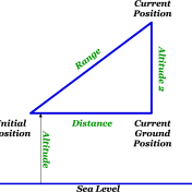
GPS 2D Distance & 3D Range

OpenTXContents Calculated sensors take values from real sensors and output data based on calculations using data from those sensors. Displays Distance on the ground Range accounting for altitude above the ground Formula Distance The distance formula uses the initial and current GPS positions to calculate the distance. A variation of distance is… Read more »
Altitude On Model Screen Top Bar

Taranis OpenTX Setup Turn on Tx Power up Rx with sensor connected Press MENU Long press PAGE Scroll down (-) till you select “—” next to “Altutude” under “Top Bar” Long press “ENT” Scroll down (-) till you select Telemetry Scroll up (+) till you select the altitude sensor you want… Read more »
GPS Altitude Relative To Ground

OpenTXContents Displays Altitude above field Auto Offset Altitude sensors usually return a value relative to sea level. If you want the model’s altitude relative to where it took off from an offset needs to be calculated. OpenTX provides a way to do this automatically. Sensor Altitude sensor Setup Turn on… Read more »
GPS – Setup

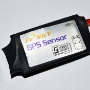
OpenTXContents Sensor FrSKY GPS (USA World) Displays Speed mph, kmh, ft/s, m/s, knots Latitude & Longitude degrees, minutes, seconds, decimal Altitude Date & Time Setup Connection diagram GPS Turn on Tx Power up Rx with sensor connected Press MENU Long press PAGE If GSpd, GPS and GALT are not visible scroll down (-) until… Read more »
Field Weather Station
BackgroundContents We live in a city where wind conditions are often different just a 15 minute drive away. We would get to the field and find a strong wind or none at all. So we had the wrong planes or didn’t bring any because we thought it was too windy. So… Read more »

