OpenTX
Contents
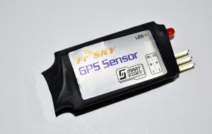
Sensor
Displays
- Speed mph, kmh, ft/s, m/s, knots
- Latitude & Longitude degrees, minutes, seconds, decimal
- Altitude
- Date & Time
Setup
- Connection diagram GPS
- Turn on Tx

- Power up Rx with sensor connected
- Press MENU

- Long press PAGE

- If GSpd, GPS and GALT are not visible scroll down (-) until to locate the sensor or select “Discover new sensors”

After they appear select “Stop discover”

- Scroll up until you locate “GSpd”

- Press ENT and then select “Edit”

- Scroll and select “kts” or what ever text appears next to “Unit”

- Scroll up or down to select your desired unit.

- Scroll down and select “Logs”

- EXIT
- Repeat for GPS and GAlt

- EXIT
Testing
- Remove the model’s propeller or take other safety precautions
- Turn on the Tx
- Display the telemetry screen showing the sensor data
- Connect a battery
- Wait until the sensor values start to show up, this could take 5-10 minutes the first time
- Observer the values displayed and compare with another reliable GPS or online data such as Google maps
This sensor is not very accurate and the readings drift with the model and GPS sensor left stationary for a few minutes. For example the height can drift by 2 meters (about 6 feet).
More
- Altitude Relative To Ground
- Altitude On Top Bar
- Distance & Range
- GPS Directions Home (Distance, Trip) Lua Script

