OpenTX
Contents
Calculated sensors take values from real sensors and output data based on calculations using data from those sensors.
Displays
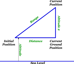
- Distance on the ground
- Range accounting for altitude above the ground
Formula
- Distance
The distance formula uses the initial and current GPS positions to calculate the distance.
A variation of distance is range which uses the same formula but accounts for altitude from an altitude sensor.
Sensor
- GPS sensor
Setup
- Turn on Tx

- Press MENU

- Long press PAGE

- Scroll down (-) until to locate and select “Add a new sensor”

- Name the sensor “Grng”

- Scroll down to “Custom” near “Type” and change it to “Calculated” by pressing “ENT”

- Scroll down to “Add” near “Formula”

- Press ENT and change “Add” to “Distance”

- Scroll down to “-” next to Unit,

- Press ENT and change “-” to the desired unit “m”

- Select “–” next to “GPS sensor” and change it to “GPS”

- Select “–” next to “Alt sensor” and change it to “Alt2”
Note: It is important that the altitude sensor selected be relative to ground

- EXIT back to the TELEMETRY screen

- Scroll to “Grng” Long press ENT and select Copy

- Scroll down untill you locate the copy “Grng”

- Press ENT, name the sensor “Gdst”

- Scroll to “GAl2” near “Alt sensor”

- Press ENT and change “GAi2” to “–”

- Exit out to the TELEMETRY screen

- Scroll down to “Screen 1”, 2, 3 or 4 and in the GPS related sensors
Instructions here

- EXIT out to the model screen and then display the TELEMETRY
Instructions here


